


|
3D Scene Modeling and Analysis The Intelligent Pattern-Driven terrain Terrain Modeling and Compression Technologies developed by Utopiacompression are capable of not only achieving superior reconstruction quality and highly efficient compression efficiency, but also providing the scalability functionality highly desired by NASA space exploration mission applications where multiple and huge amounts of NASA imageries are required to be reliably and rapidly sent back to earth. Traditional modeling and compression schemes do not have the capabilities to take advantage of recognizable conceptual primitive visual patterns. Contrary to this disability, UCs 3D terrain surface modeling and compression technology perceives visual data as a collection of regions with distinct patterns and therefore focuses on efficient and effective linear and non-linear modeling methodologies to represent visual patterns using minimal sets of features (extracted by applying statistical machine learning to generate a knowledge base of such patterns). Furthermore, UCs surface modeling and compression is multi-resolution by nature, which in turn provides the scalability functionality highly desired by network-based data transmission and visualization applications where heterogeneous network and end-user devices exist and pose different requirements and restrictions to the modeling and compression systems. These scalable capabilities are mostly desired by NASA space exploration mission applications where multiple and huge amounts of NASA imageries are required to be reliably and rapidly sent back to earth. Furthermore, the integrated terrain surface meshing, encoding and decoding prototype achieves superior reconstruction quality and highly efficient compression efficiency. Modeling and compression samples are shown in the pictures. 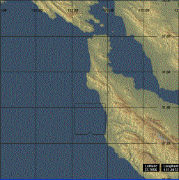 Original 1 degree DEM data for west Long Beach (obtained from USGS) 
UC reconstructed DEM data (RMSE=18; Compression Ratio = 1202)
Original 1 degree DEM data for east Long Beach
UC modeled and compressed DEM data (RMSE=29; Compression Ratio = 354) |
||
Home | Company | Research and Development | Careers | News | Contact
© 2007 UtopiaCompression. All Rights Reserved.